Fredrik Marine

NAL9602 Discreet Vessel Tracking

Jaden Lee 

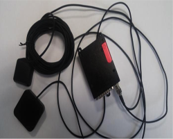
The NAL-9602 is an ultra-low power consumption tracker designed for SBD data communication using the Iridium® satellite network. The beauty of the NAL9602 is that this transmitter looks identical to your average USB cable, allowing it to be hidden anywhere on board. The NAL 9602 utilises that Iridium satellite constellation to track your vessel and fleet, thereby ensuring global coverage.

In the event of piracy attacks which are getting more and more commonplace, this discreet tracker allows ship managers and ship owners to know where their ship is at, reducing the time in locating the ship – excess time that might endanger the crew’s life.  The NAL9602 can be installed even without the crew knowing about it and ship managers will know if there are abnormal deviations from the planned voyage route.

Model 9602-LP can send either standard or 256-bit AES-encrypted GPS reports at a pre-programmed interval ranging from once every four seconds to once every seven days. The interval can be changed remotely while the unit is in the field. As for power, an input voltage between 5 and 33 volts is all that is required. Although it is recommended to install the antenna in clear view of the sky, it can also be installed in a fibreglass boat. This installation needs to be tested before being approved.


Features

  • Internal Motion Sensor
  • 2 RS232 level I/Os for sensor interfaces
  • 7 TTL/CMOS level I/Os for sensor interfaces
  • GPS Sensitivity of –160dBm
  • Standby current of less than 65µA
  • Wide input voltage range from 5V to 32V
  • Internal Motion Sensor
  • Two (2) RS232 level I/Os for sensor interfaces
  • Seven (7) TTL/CMOS level I/Os for sensor interfaces
  • GPS Sensitivity of –160dBm
  • Programmed for either Commercial or DoD Gateway
  • Supports NAL Research and PECOS formats
  • AES 256-bit encryption for both transmission and receiving
  • 2 way communications
  • Real-time reporting


Advantage

  • Discreet ship and vessel tracking solution
  • Global coverage
  • Affordable
  • Improve crew safety


Dimensions & Weight

Length 69mm (2.73”)
Breadth 55mm (2.17”)
Height 24mm (0.94”)
Weight 136g (4.8oz)

Shipping dimensions & Weight

Input Voltage 3.6V to 5.5V or 6.5V to 32V
Avg Current (Report) 200mA @ 5V Input (Sleep) < 65µA @ 5V Input
Operating Temp –40°C to +85°C (–40°F to +185°F)
Operating Humidity < 75% RH
Iridium Frequency 1616.0 to 1626.5 MHz
GPS Frequency 1575.42Hz (L1 carrier)

Recommended Posts

MAR-GE/T Floatable Terminal

The MAR-GE/T Floatable Terminal was designed primarily for Marine equipment monitoring, oil spill tracking, and current/drift studies. This terminal has an integrated GPS data logger, allowing it to report up to 96 accurate positions daily. Little maintenance is required as the device is simple and highly autonomous – it can last up to 250days. The beacon is waterproof and buoyant, allowing it to be spotted easily. The beacon is simple to install as no special tools are required and can be completed in less than 10 minutes. Operation is also simple as there are only 2 buttons and 1 LED light to indicate the status of the beacon. This terminal can also transmit a “request for assistance message” in addition to the normal positions. When the request is activated, the beacon transmits to the ARGOS system and the GPS position is logged every 15 minutes. Such help requests are directed to nearby fisheries offices to send out a rescue vessel. Similar to the rest of the products by CLS, there is full global coverage with the ARGOS satellite constellation, the brainchild of various international space agencies. Fredrik Marine recommends using the MAR-GE/T to secure unpowered floating units, which are mainly under the purview of port authorities or to monitor small traditional fishing boats.   Features High Autonomy*: > up to 450 days in operation, can last more than 5 years in storage Compatible with ArgosWeb Mapping interface for drifting monitoring Compatible with ARGOS Geofencing services (incl. alerts) Built-in GPS receiver for accurate positioning Extra ARGOS positioning (incl. speed and heading) LED indicator for operations control Battery options: rechargeable or disposable\ Extra ARGOS positioning (incl. speed and heading) LED Indicator for operations control Battery options: rechargeable or disposable Robust all-in-one design for marine environment Configurable GPS acquisitions & transmission rates, etc. *Autonomy of the units depends on the configuration, the environmental conditions and can be affected by ageing and maintenance quality.   Dimensions & Weight Diameter (max.) 134 mm Height 280 mm Weight 1.0 to 1.3 kg (depends on the battery type)   Shipping dimensions & Weight Diameter (max.) 134 mm Height 280 mm Weight 1.0 to 1.3 kg (depends on the battery type)   Technical Specifications Environmental specs. Operating Temperature -20 °C to +50 °C Storage Temperature -25 °C to +70 °C Water Resistance IP67 Certified (immersion up to 1m) Power Rechargeable batteries NiMH 4.5 Ah Non-rechargeable batteries Lithium 26 Ah or 38 Ah Autonomy Storage > 5 years in optimal conditions (5-30°C) Data Transmission Satellite System ARGOS Coding Binary Transmission Period 30 to 240 s (configurable by CLS)   Technical Specifications RF specs. Transmitter type CNES certified ARGOS Transmitter Output RF Power 32 dBm (1.5W) Output Frequency 401.650 MHz ± 30 kHz GPS Receiver type Fastrax IT500 Acquisition period 15 / 30 / 60 min Precision 1 to 100 m (configurable by CLS) Deployment From Vessel Up to 30 m shockproof Air-borne (helicopter) Up to 30 m shockproof   Downloads MAR-GE/T Brochure

Jaden Lee 

NAL9602 Discreet Vessel Tracking

The NAL-9602 is an ultra-low power consumption tracker designed for SBD data communication using the Iridium® satellite network. The beauty of the NAL9602 is that this transmitter looks identical to your average USB cable, allowing it to be hidden anywhere on board. The NAL 9602 utilises that Iridium satellite constellation to track your vessel and fleet, thereby ensuring global coverage. In the event of piracy attacks which are getting more and more commonplace, this discreet tracker allows ship managers and ship owners to know where their ship is at, reducing the time in locating the ship – excess time that might endanger the crew’s life.  The NAL9602 can be installed even without the crew knowing about it and ship managers will know if there are abnormal deviations from the planned voyage route. Model 9602-LP can send either standard or 256-bit AES-encrypted GPS reports at a pre-programmed interval ranging from once every four seconds to once every seven days. The interval can be changed remotely while the unit is in the field. As for power, an input voltage between 5 and 33 volts is all that is required. Although it is recommended to install the antenna in clear view of the sky, it can also be installed in a fibreglass boat. This installation needs to be tested before being approved.   Features Internal Motion Sensor 2 RS232 level I/Os for sensor interfaces 7 TTL/CMOS level I/Os for sensor interfaces GPS Sensitivity of –160dBm Standby current of less than 65µA Wide input voltage range from 5V to 32V Internal Motion Sensor Two (2) RS232 level I/Os for sensor interfaces Seven (7) TTL/CMOS level I/Os for sensor interfaces GPS Sensitivity of –160dBm Programmed for either Commercial or DoD Gateway Supports NAL Research and PECOS formats AES 256-bit encryption for both transmission and receiving 2 way communications Real-time reporting   Advantage Discreet ship and vessel tracking solution Global coverage Affordable Improve crew safety   Dimensions & Weight Length 69mm (2.73”) Breadth 55mm (2.17”) Height 24mm (0.94”) Weight 136g (4.8oz) Shipping dimensions & Weight Input Voltage 3.6V to 5.5V or 6.5V to 32V Avg Current (Report) 200mA @ 5V Input (Sleep) < 65µA @ 5V Input Operating Temp –40°C to +85°C (–40°F to +185°F) Operating Humidity < 75% RH Iridium Frequency 1616.0 to 1626.5 MHz GPS Frequency 1575.42Hz (L1 carrier)

Jaden Lee 

VELA Ship Tracking Terminal

VELA terminal is a ship and fleet tracking solution from CLS. It is a low-cost ARGOS/GPS transmitter that has been designed for maritime tracking on board ships with an IP66 dome. Position, speed and heading of vessels are transmitted by the ARGOS satellite constellation, the brainchild of various international space agencies. For ship managers or owners looking for a low-cost yet reliable tracking solution, look no further than VELA. The reason for VELA terminal being more affordable is that the VELA terminal utilises ARGOS transmissions that are not real-time but serves its purpose of tracking vessels sufficiently. Although tracking is delayed, it is possible to get a position every 15 minutes if required.   Features Full Global Coverage GPS positions reported at regular intervals (every 15mins) GPS module with high sensitivity for fast position fixing Robust all-in-one design for harsh maritime environment Easy to install Immediate activation Robust design to withstand harsh maritime environment Light display on interface box to indicate power quality and active transmissions Isolated supply, wide input voltage and EMC/EMI compatible Back up battery in case of main board failure: 48 hours continuous operation   Advantages Affordable Vessel and Fleet Tracking

Jaden Lee